

Conference
GPS:
BOW S 31° 40.288'
E 115° 39.646'
STERN S 31° 40.278'
E 115° 39.618'
Location: Mindarie
Site depth: 16 metres
Divable conditions: <1.5m swell
Visibilty: 5-15metres
Vessel: Stripped hulk
Construction: Steel
Tons: 420 ton
Vessel length: Unknown (site length ~45m)
Wreck event: Scuttled 1905

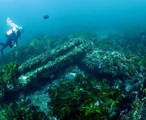
Bow section and Bowsprit mast step of the Conference
The wrecksite lays two miles north west from Mindarie marina. Although collapsed, the site is still easily recognisable laying on a north west to south east axis, stretching for 45 metres from the stern post to a section of the bow intact and laying on its side to the south east.
The rudder and stern post is the only upright structure left of the 420 ton iron barque named the 'Conference'. Built in 1855, after 40 years of service the Conference was hulked in Albany a decade before the vessel was finally scuttled in 1905.
The site is a easy dive over broken and undulating limestone reef. Finding a snad hole to anchor in can be difficult at the site as visibility from the surface to the seafloor can be dificult due to the depth of the site. There are a number of small sand patches near the bow where the anchor can be repositioned by divers to lay in sand on descent.
In 2023 the site was revisited for accurate positioning of the bow and stern locations to aid in accessing the site. A full 3D photogrammetry model was also completed on site to add to our database and catalouge. It was also observed the the steering quadrant of the rudder post has since deteriorated and collapsed at the stern of the wreck.


Below is the 3D representation of the Conference site. The site proved to be a challenging capture mainly due to the heavy kelp beds that cover the site and their constant movement in the surge. This, and the undulating topography of the broken limestone reef made the capture slightly more difficult than most models.