
Freshwater Bay
Freshwater Bay is situated opposite Point Walter and includes the areas of Mosman Park and Claremont. The bay is surrounded partially by cliffs and the most accessible entry points are the areas surrounding the Royal Freshwater Bay Yacht Club to the south western end of the bay and the area surrounding Claremont Yacht Club to the north of the bay. Both areas are easily accessible with nearby parking and grassed areas for kitting up and briefing.
During 2017 we extensively covered the bay with a side scanning echo sounder and located a number of interesting and previously unknown wrecks and objects in the bay. The larger targets seem initially to be modern day examples of vessel abandonment. Of the 3 larger intact boats, two are stripped of all identification and chandlery that were possibly sunk on purpose to avoid scrapping and the other larger vessel was located at the base of a mooring, still intact, identifiable and had only been underwater for less than 12 months.
Currently Freshwater Bay is still a work in progress for us, we have investigated the larger targets and likely wrecks from our above water searching but we still have quite a number of smaller targets to dive and identify over the coming months the page will be updated accordingly.

Of the three main wrecks listed for Freshwater Bay, only one is easily accessible to all divers from shore. The McGrief is located on the edge of the moorings in front of the Royal Freshwater Bay Yacht Club, it can be reached from the nearby grass or jetty to the west of the moorings. The Jetty is all that remains of the old site of the McFarlands Boat Shed and Tea House. The Two other sites listed lay along the cliffs on the western side of the bay and are reached easily by boat or watercraft, although being interesting, modern wrecks in good condition they are small targets to try and locate using bearings swum over long distances.
Wreck: McGrief
Position: S 31° 59.871'
E 115° 46.362'
Nearest Mooring: 079
Entry Point: Freshway Bay Yacht Club - Old McFarlands Boat Shed Jetty
Bearing from mooring to wreck: 10 metres @ 070°
Bearing from entry point to mooring: 120 metres @ 110°
Construction: Wood/Steel
Dimensions: 5.82 x 2.17 metres
Depth: 12 metres
The McGrief was located on our second scan of the mooring area opposite the Royal Freshwater Bay Yacht Club, it had been missed on the previous scan two months earlier by only a matter of metres or had perhaps not been there during the first scan. A dive inspection of the McGrief site showed a very current registration sticker and had likely been underwater at most 12 months, also by viewing Google maps in street view the McGrief could still be sitting on its mooring above water with the imagery used by Google dating 2016. The McGrief site was found to be an environmental hazard, we surfaced to the smell of diesel on the surface and noticed fuel oil on the interior roof of the cabin. The wreck was reported to the authorities and was being investigated to be removed by the owner, on the last check in Freshwater Bay the wreck was still in place.
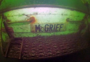


The wreck can be located from shore near the site of the old McFarland's boat shed (the jetty) near the end of Leake Street, parking is easily accessible nearby and the wreck can be found sitting upright in 12 metres of water only 10 metres from the nearest mooring (079). Being a recent vessel that seems to have sunk without warning on its mooring, large amounts of rope and flotsam can be found inside the cabin and the surrounding area causing a hazard of entanglement. Also the presence of diesel and chemicals were found leaching from the cabin, divers should be aware that any physical disturbance of the wreck will likely result in the pollution of the surrounding environment and contact with the hull should not be attempted for this reason.
Claremont Cliff Wrecks

Wreck: Cliffs -
Motorboat 1
Position: S 31° 59.606'
E 115° 46.404'
Nearest Mooring: N/A
Entry Point: Boat
Bearing from mooring to wreck: N/A
Bearing from entry point to mooring: N/A
Construction: Wood
Dimensions: 5.1 x 2 metres
Depth: 11 metres

Located 300 metres north along the cliffs from the old McFarland's Boat Shed site (Jetty) and Royal Freshwater Bay Yacht Club, the Motorboat site is virtually unreachable as a shore dive beside for the most prepared divers. The boat is reasonably small and a very easy target to miss while swimming on a bearing. It is however a pretty neat little wreck that sits upright fully intact and has likely been scuttled by its owner deliberately. The little wooden motor boat lacks any identification, anchors or fittings necessary to the running of the boat, perhaps indicating it was stripped down before it found its way to the river bed. The wreck seems stable and doesn't appear to be leaching any chemicals into the surrounding area, in the centre of the back deck sits an old Lister Petters diesel engine.


The Motorboat 1 site is a small but interesting wreck, it is best dived in the morning and midday before the sun is obscured by the cliffs giving the impression of a poor visibility dive. The easiest way to approach the wreck with a boat is to drop a shot line on the site and anchor off to one side to avoid damaging or disturbing the hull. In good light the nearby cliffs can be an interesting dive to finish a tank off and at the right time of year crabs seem to be prolific. The wreck also sits near the boating channel so be aware of boat traffic when diving the site.
Wreck: Cliffs -
Motorboat 2
Position: S 31° 59.517'
E 115° 46.391'
Nearest Mooring: N/A
Entry Point: Boat
Bearing from mooring to wreck: N/A
Bearing from entry point to mooring: N/A
Construction: Wood
Dimensions: 6.1 x 2.5 metres
Depth: 8 metres
Located closer to the northern end of the cliffs, closer to the Claremont Yacht Club lays the second Motorboat site for Freshwater Bay. The wooden boat sits with its bow facing the east leaning on its starboard side. The vessel also has a lack of fittings and chandlery and was possibly a motor sailor. Although it has a mast post and deep keel there is no mast present on the site. This boat seems to have been down the longest and has damage to the hull on the port side below the water line, whether this is deterioration of the hull while being underwater or in fact the reason for the sinking, it remains to be unknown.


Like the Motorboat 1 site, there are no nearby moorings to orientate from and no nearby entry points, it's recommended that the site is really only accessible by boat. The wreck sits at a depth of 8 metres and is an easy wreck to cover and move on along the cliffs, boat traffic is also a hazard as the wreck sits along the edge of the marked channel.
Tenders
We've located four sites in Freshwater Bay that show on the sidescan images as small dinghys or tenders for larger boats, all have been found in the immediate vicinity of a mooring and all but one are yet to be investigated and accurately positioned. Work on the Freshwater Bay section of the site will be ongoing as the bulk of our sidescan targets are dived and updated to the site, usually small dinghys under 3 metres of length haven't been included in the site as they hardly rate as an attraction for a dive. Anything of interest will be posted in the coming months.
Side Scan positioning can show varying degrees of inaccuracy up to 10 to 15 metres depending on the width of the sweep. GPS positions listed for the tenders haven't been verified or collected accurately by diver and DSMB and may have slight inaccuracies.
Tender 1: S 31° 59.906' E 115° 46.370'
Tender 2: S 31° 59.935' E 115° 46.479'
Tender 3: S 31° 59.366' E 115° 46.575'
Tender 4: S 31° 59.574' E 115° 47.161'